About the Central Rhyl Coastal Defences Scheme
Jump straight to:
Rhyl is a well-loved seaside town with many homes and businesses located along the seafront.
The central area of Rhyl (approximately between Splash Point to the east and the Children's Play Area, opposite John Steet, to the west) is currently protected by sea defence structures. However, these are deteriorating and, if no work is carried out, they could fail within the next 10-15 years. Currently, 548 residential and 44 non-residential properties are at predicted to be at risk from flooding.
The purpose of the scheme is to improve coastal flood defences in Central Rhyl to protect homes, businesses and the tourist economy from flooding events and coastal erosion well into the future.
Funding has been granted.
The pre-application consultation period for the Central Rhyl Coastal Defences Scheme ended on 09 February 2022. A public exhibition for the scheme was held at Rhyl Town Hall on 25 and 26 January 2022.
The planning application was submitted to Denbighshire County Council and is available to view online. The application reference is 45/2022/0271.
Planning was approved for the scheme in July 2022.
Should you have comments relating to the planning application, these should be directed to Denbighshire County Council's Planning Department.
Marine Licence - A Band 3 marine licence from Natural Resources Wales has been obtained to ensure compliance with the Marine and Coastal Access Act 2009 (external website).
This map shows the extent of possible flooding in Rhyl and illustrates the flood risk to properties if coastal defence improvements do not take place:
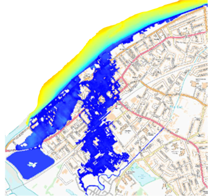
Predicted flood extent in 2118 based on current defence heights, for a flood event that has 1 in 200 (0.5%) chance of happening in any year.
The coastal defences at Rhyl were originally built at various times between 1900 and 1920 and no longer meet current standards. Without intervention, they will ultimately fail. We need to replace them at the earliest opportunity to reduce the risk of flooding and to support the regeneration of Rhyl.
The Central Rhyl Coastal Defences Scheme covers a distance of approximately 2km from Splash Point to the Children's Outdoor Play Area, opposite John Street.
The standards of defences required have changed since the existing defences were constructed, which means they cannot be replaced 'like for like'. We have considered a wide range of options for improving existing coastal defences in Central Rhyl in line with the standard of protection provided by the adjacent defences at East Rhyl (completed in 2021) and West Rhyl (completed in 2015).
The preferred option that has been selected via a comprehensive options appraisal process in line with Welsh Government guidance, comprises two distinct sections:
- The eastern section (coloured green on the map below) which runs from Splash Point to approximately SeaQuarium and Rhyl Events Arena.
- The western section (coloured blue on the map below) which runs from SeaQuarium to opposite John Street.

The eastern section will predominantly consist of rock scour protection to the foundations of the existing defences plus concrete repairs to the existing defences.
The scour protection will consist of boulders being placed at the base of the existing structures.
This will be mostly buried beneath the existing beach level and there will be walkways through the rocks to maintain beach access:
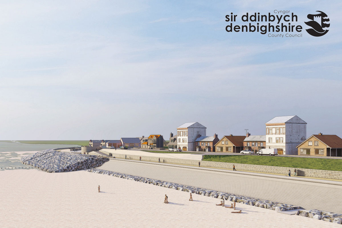
The western section will consist of a new stepped revetment, raised and widened promenade and new seawall.
Improved access (via steps and a ramp) to the beach will also be provided in the western section:

We will put measures in place to mitigate any disruption and environmental impacts that may arise as a result of the construction; for example, impacts on noise levels, vibration, or air quality.
In July and August 2021, we asked for your feedback on the scheme, including the flood defence options we might use, to find out what is important to you, what benefits you think the scheme could bring and any concerns that you may have.
162 people responded to the online survey. Here are the highlights:
Your top three most important considerations as we develop the scheme were:
- Sea views/the scheme needs to look nice (85% rated this as ‘very important’)
- Easy access to traffic-free cycle and walking routes (72%)
- Easy access to public toilets (69%)
Your top three potential benefits of the scheme were:
- Increased resilience to flooding and coastal erosion (81% rated this as ‘very important’)
- Improved look for the beach and promenade (79%)
- Improve existing access to beach (70%)
Feedback from the survey also showed some common concerns including:
- Keeping the beach and promenade accessible during and after construction
- What the defences will look like
- Potential impact on businesses/tourism while work is taking place (particularly during peak tourism times)
- loss of the existing sandy beach
- Potential barriers to sea views.
We would like to thank everyone who completed the survey, we will take your views into account as we progress the scheme.
Construction of the scheme is expected to take approximately two and a half years.
Construction of the western section, from SeaQuarium to John Street, will be ongoing throughout the full construction period from February 2023 to October 2025.
The eastern section from Splash Point to the SeaQuarium is expected to take around one year from March 2023 to March 2024.
The main compound will be situated within the existing Balfour Beatty compound on Marine Drive. There will also be an additional temporary compound at Quay Street. A number of temporary site access points will be installed at the Eastern side and Children’s Outdoor Play Area (opposite John Street).
Balfour Beatty’s normal working hours on the promenade will be Monday to Friday between 07:00 and 19:00. Saturdays will only be by prior agreement with the Council. Works on the beach will follow irregular working hours to suit the daily tide times.
We will put measures in place to mitigate any disruption and environmental impacts that may arise as a result of the construction; for example, impacts on noise levels, vibration, or air quality.
Two construction routes will be in use to supply the required materials during the scheme’s development.
These are:
- From the A55 following the A525, entering the scheme area from the west
- Via the A548 from the east
Promenade Closure
The promenade will be closed from February 2023 through to October 2025, between SeaQuarium and John Street. Adequate diversion routes will be implemented where required.
Localised promenade closures will be from March 2023 through to March 2024 from Splash Point to Rhyl Events Arena.
All beach accesses will be re-routed to the nearest accessible paths which will be agreed with Denbighshire County Council.
As of 2 April 2025, the promenade access from John Street to Shack Fish & Chips will be closed and re-diverted towards East Parade Road, joining the existing re-diversion route. Shack Fish & Chips will remain open as usual. This closure will be in place until construction work is completed by Autumn 2025. Signage will be in place with the clear diversion route. We apologise for any inconvenience this may cause.
2025
Central Rhyl Coastal Defence Scheme Newsletter - Issue 15 (August 2025) (PDF, 566KB)
2024
2023

Balfour Beatty is registered with the Considerate Constructors Scheme
This means we are visited by Scheme Monitors who assess how well we are performing as a considerate constructor, in line with the Scheme's Code of Considerate Practice.
Organisations registered with the Considerate Constructors Scheme make a commitment to conform to the Code of Considerate Practice:
- Respect the Community
- Care for the Environment
- Value their Workforce
If you have a concern about this construction site or would like to provide feedback, contact us on:
To find out more about construction activity in your area, visit: www.constructionmap.info (external website).